


 texto em
  Inglês (pdf)
 Artigo em XML
 Referências do artigo
 Enviar este artigo por email
 Citado por SciELO
  Similares em
SciELO
Similares em
SciELO 
 Permalink
1 INTRODUCTION
Cultural tourism routes in Serra Gaúcha are deeply rooted on past memories from the process of immigrant settlement, particularly of Italian origin. This is also observed in the collective imagination of the current inhabitants, who often choose to emphasize their ancestors' roots. The present work analyzes, through graphics and observation, the tourist trails routes in the region by overlapping them to the migrants' tracks and routes used during the settlement of the old colonies, and in the formation of the cities in the northeast Rio Grande do Sul state, in the southern Brazil.
For decades, culture has been the main tourism product in the region. Tourism activity uses as a resource the transposition of European identity, linking it to the culture of the Italian peninsula, through food, architecture and other characteristics of local daily life. The identification of old vicinal roads, also occurs. They clarify the occupation of the territory, defining a socio-cultural axis distributed into various interlinked agricultural communities. The roads gave support, and still do, to a model of family economy based on small-scale agriculture. The process started in the late 19th century with the occupation of unclaimed lands located in the interior of the State (at the time of the Province of São Pedro do Rio Grande do Sul).
During colonization, a long strip of land in the northeast of the Province was used by the Imperial Government for agricultural purposes. Immigrant colonies were formed having as a reference for territorial administrative control the respective seats. The superstructure logic was determined by the imperial policy of "organized and structured formation to receive the immigrants, or migrants, interested in buying lots of land" (Giron, Nascimento, 2010, p. 30), in order to establish the foundation of the socio-spatial reproduction of the region. Conde d'Eu, Caxias, and Dona Isabel colonies (now the municipalities of Garibaldi, Caxias do Sul and Bento Gonçalves) were the first to be created. There is plenty of historical data about them, as well as past and present maps, which enables the understanding of the regional establishment in the territory. These data add values which clarify and depict the scenario of their social, economic and cultural production, among other specific and peculiar aspects.
Thus, "the winemaking activity was of great importance to the establishment of the Italian culture in south Brazil and, especially, to the economic development of the Serra Gaúcha region" (Losso, Pereira, 2012, p.185). The understanding of this occupation is important in various domains. Its formation was an example of a pioneering initiative of regional planning. Defined in the 19th century by imperial agents, often detached from the real situation, spatial reproduction (physical and social) present unique features, with values which enable physical, territorial and tourism planning.
In this context, all the complex regional structure allowed for the planned settlement of successive waves of immigrants in the 19th and the 20th centuries. Currently, the region is a reference in terms of wine tourism in Brazil and it creates routes taking into account the existence of old roads associated to memory. This research aims to analyze if this appeal of memory (Halbwachs, 2001), matches the legacy of regional urban transformations, and to what extent they result from these memorial conditions. This study in Serra Gaúcha looks into the unique features related to pioneering initiatives of tourism activities. By identifying and studying the former roads, which led to the social-demographic settlement, the possibilities for creating tourist routes will be assessed. When these roads became structural roads the old paths were often altered, remaining the primitive connections as secondary routes with a strong appeal of memory. Therefore, based on the fields of Human Geography and Urban History, this study aims to understand the process of tourism planning and its relationship with the heritage of established cultural regions and its contribution to urban networks. The research draws on a theoretical approach on the evolutionary process of the region, distancing itself from the traditional concept of History and closer to an ontology related to a spatial dimension (Sposito, 2004).
2 METHODOLOGY
The roads of the agricultural colonies of Serra Gaúcha are the object of this study. They are analyzed as a resource for the tourism product. Many tourist routes consider these roads as historical benchmarks from the settlement period and a reference of the connection between locations. The question is: Do this routes reflect a given historical, memorial and territorial context or are they idealized for tourism purposes?
The territorial contour is perceived through an approach close to the historical-genetic method (Lefébvre, 1986). In this way, the factors related to the Historical or Vertical Complexity are examined allowing for "the observation and analysis, and the coexistence of formations of different ages and dates", (Lefébvre, 1986, p. 166). In spite of this, there are still other research possibilities. The research is built upon the regional geographical formation (Lencioni, 2003), the memory (Choay, 2011) and on the social production of space (Lefébvre, 2004). In this manner, the juxtaposition of modernity and archaic, once it entails narrow epistemological configurations, generates the search for understanding, justifying its territories, departs from the networks in question and, in them, the tourism appropriation.
The process of settlement in Serra Gaúcha was established through a series of directions defined by the cartography, and other decisions made prior to the immigrants' arrival. These documents are clear about the occupation process. Thus, the analysis of maps and documental resources about that process is aimed at understanding the definition of the settlement structures, as well as the routes which made possible the regional and interregional exchanges.
The region stands out today as an important driver for national tourism activity (Brasil, 2006; 2007). Besides the strong presence of wine tourism, there are also several tourist routes based on historical and cultural heritage. This draws on the memorial values linked to the Italian settlement, their traditions, food and architecture. Given this context, it is intended the identification of these tourism routes. Concurrently, documentary sources are examined, including advertisement material.
This research examines the immigrant pioneer towns of the region, i.e. Caxias, Dona Isabel, and Conde D'Eu (Figure 1). However, the limits are not circumscribed to the current municipalities, given that there are routes surpassing the administrative borders. Regarding the temporal aspect, the initial settlement structures are presented, i.e. the road structure that enabled the arrival and establishment of immigrants and its productive characteristic. Along these roads and structures small hamlets were established giving rise to the whole process of regional settlement
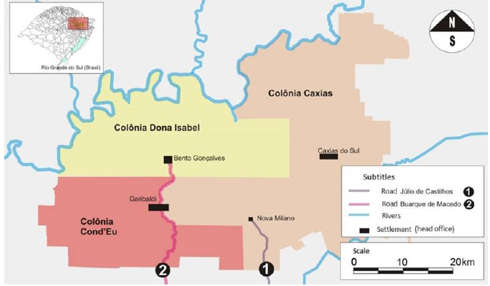
Source: Adapted from Gallo (1976)
Figure 1 Croquis of the colonial territory division of NE Rio Grande do Sul (Brazil)
The guiding question is the search of the understanding that the cultural tourism routes are presented as representation and memory reference of the old colonial tracks. Thus, in this study the objective is to identify the structures of the regional urban settlement, comparing it with the structures of the current tourism routes. This acknowledgment can be useful for other studies, as it identifies new ways of appropriation and spatial logics, based on the Theory of Location (Ablas, 1982).
Several maps and croquis were prepared. In these materials the current situation is presented, the land use, the process of formation, as well as atemporal representations, or of multiple temporality. There, the flow structures (roads or waterways) in the time of the settlement are marked, as well as the ancient hamlets. Changes defined by confrontation of temporalities, call by Santos as "roughness" (Santos, 2002), are observed.
Concepts and theories are adopted knowing that "no theory ever agrees with all the facts in its domain, yet it is not always the theory that is to blame" (Feyerabend, 1977, p. 77). The comparison between the Theory of Regional Sciences, of Regional Planning as a field of knowledge, and the specificity of Tourism Planning is done within a theoretical framework of structural complexity, in which the disarticulation is justified by novelty and the implication of fields that usually are not linked. After all "theory is full of imperfections. However, it can by improved and developed" (Feyerabend, 1977, p. 288).
The objects of the study were selected based on Brambatti's (2005) inventory of tourism resources based on routes in Serra Gaúcha. The age of the routes is highlighted, allowing for a better understanding of them as tourism products and attractions. All of the routes are established for more than a decade which allows the recognition (or not) of their consolidation through tourist spatial and institutional appropriations. Thus, this research adopts as reference the consolidation of the territory appropriated and changed by the tourism activity (Guerrero; Guallucci, 2015).
The survey of the tourism routes is made through two aspects: a formulation established by years or decades and having tourism facilities. At this point of the research, unsystematic observation takes place (Denker, Da Via, 2001) in order to apprehend the reality and, thus, rule out projects still in consolidation. The tourism offers and practices are verified in those places, identifying them by comparison to graphic representations. In this insertion "the gaze directs the focus and the angles of vision, it creates a visual field; seeing means paying attention, notice and perceive, single out things within that wide vision conferred by the gaze" (Gomes, 2013, p. 32). In this way, the observation in loco allows, besides recognizing the object, the presentation in graphic representations. The spatial positioning of their "location format" (Gomes, 2013, p. 36) is sought, their values conveyed by social logics, by their territorial production and, also, regarding those impositions, the development of scenarios.
The examined region, although considered a recent settlement (late) (Diégues Junior, 1965), has a consolidated tourism for more than half of its regional formation (early) (Gastal; Machiavelli, 2013). In Serra Gaúcha, the transposed cultural memory is the key resource of tourism, justified in the individual or collective stories of immigrants.
3 THE OCCUPATION CONDITIONS OF THE MIGRANT COLONIES
In the northeastern Rio Grande do Sul a slope region stood out, almost uninhabited. Geographically, the area was adequate for productive development. Furthermore, in that period, an alternative to the hegemonic structure based on slave labor and large estates was sought. Thus, from the 1870s, the Imperial Government of Brazil orders and outlines the policies to occupy Serra Gaúcha. This settlement was planned at a regional, large-scale level. It is also noteworthy the adoption of a road structure between the main populated places. Even if these were small communities, the roads support the establishment of tens of thousands of people, strengthening the development of an immigrant cultural region and deepening the various interregional flows (Giron, Nascimento, 2010).
The Europeans' search for new conditions of life meet the geo-economic interests of local/national government. Thus, after a long journey, tens of thousands European immigrants arrived in South America, particularly in the capital city of the province of Rio Grande do Sul. After disembarking at a distance of just over 100 kilometers of the area to be colonized, their penetration into the continent was done by waterways to Montenegro (RS) and São Sebastião do Caí (RS). In this way the connection between Montenegro and Conde d'Eu was established, creating the Buarque de Macedo road, and also Júlio de Castilhos road, from São Sebastião do Caí to Nova Milano, the first seat of Caxias colony. These roads are acknowledged as the first land connection in Serra Gaúcha (Figure 2).
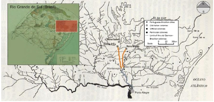
Source: Adapted from Gallo (1976; Roche, 1969, p. 111)
Figura 2 Penetration route of the immigrants in Serra Gaúcha
The approval of the Land Law (1850), years before, established legal security in land settlement, recognizing private property. The immigrants occupied small lots of land, besides urban lots in the colonial seats, thus, becoming the fundamental agent of privatization and rural subdivision. This was done following a distribution by a spacing in leagues, with the lots linked together by lines, dots or dashes: "The line determined the social structure and the organic unit of the populated places, the immigrants organized their religious and social life according to the model of their Italian hamlets. The difficulty of communication between lines and dashes strengthen these little communities, which spread throughout the region" (Machado, 2001, p. 48). The formation of the regions is defined in the social and quotidian space dimension.
This situation contributed to the spatial logics imposed by the intendants. "When planning the colonization, the imperial officials were already thinking about creating urban and rural areas. Every colony should have a seat, which would have not only the political function of being home to the director and imperial personnel, but also it should have both an economic role, as a place of commerce, and a religious function, receiving the Church and the priests" (Giron, Nascimento, 2010, p. 78). However, this spatial planning overlooked the topography, except for the areas near the main rivers (Antas and Taquari). The dimension of the lots was small and the families were large, therefore the internal migrations occurred (Frosi, Mioranza, 2009). These movements led to new population centers, e.g. the ones that gave rise to the cities of Monte Belo do Sul and Santa Teresa, before part of the Dona Isabel colony. Levels of regional expansion in the occupation as a whole are defined.
The first colony to receive immigrants was Conde d'Eu which, in 1871, it had eighty lots. However, the largest flows occurred from 1875 onwards, having as a starting point the first league of Caxias colony, in the district of Nova Milano. In the Barracão (Shack), the building where the government establishes some legal, administrative, and technical structure, the workers and families were directed to their land lots, besides receiving seeds and tools (Gardelin, Costa, 1993). The planned nature of the settlement was reinforced by occasional actions.
The region under study is characterized by the Araucaria forest and rough terrain of mountains and valleys. There, the roads were built, called "picadas", i.e. tracks which connected the areas of expansion to the seats. The seat Caxias (now Caxias do Sul) and Dona Isabel (now Bento Gonçalves), as spreading points, established the settlements and the predominant logic of social and spatial reproduction. The Caxias Colony stands out early in the urban hierarchy of the region.
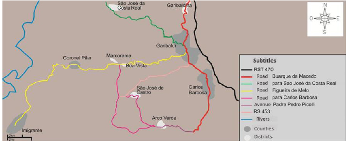
Often, the immigrants that arrived in Nova Milano (Caxias Colony), moved to Dona Isabel (Bento Gonçalves) by Júlio de Castilhos road. However, the main arrival route of the immigrants that settled in Cond'Eu, was through Buarque de Macedo road (CDU, 1987). Dona Isabel Colony profited from these two accesses. In 1874, a track was opened in the colonial line Figueira de Melo (now, Coronel Pilar), enabling the arrival of more new immigrants (Figure 3).
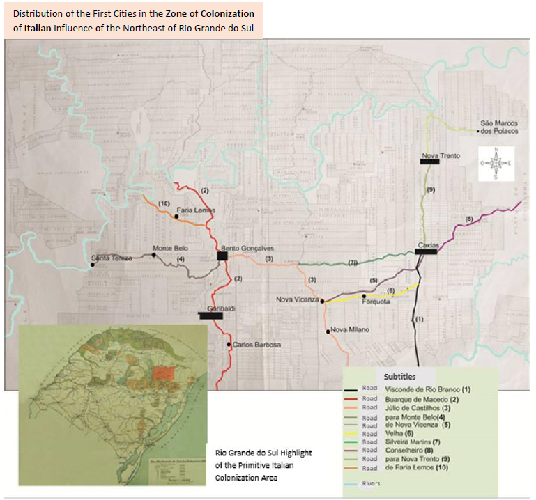
Source: Adapted from Gallo (1976)
Figure 3 Early roads of the colonization of northeast Rio Grande do Sul
In the seat of Dona Isabel Colony the first immigrants concentrated in a clearing with favorable topography. In this place a shop, a church and the first town houses were built, becoming later part of the city center of Bento Gonçalves (downtown). This population center spread to east and north, following the most favorable terrain within an intermediate plateau.
In 1881, following the opening of Buarque de Macedo road, between Bento Gonçalves and São João de Montenegro, the expansion went north, structuring the populated place linearly. To the east the expansion is made around the Júlio de Castilhos road, which connected what is now the city of Farroupilha to Barracão of Dona Isabel Colony, located in the beginning of Palmira line. From Júlio de Castilhos road it is built Silveira Martins road, which was the first to be directly connected to Bento Gonçalves. Subsequently, the railway connection between Bento Gonçalves and Porto Alegre, in 1919, gave rise to urban growth in the south slopes, creating a new populated place, almost separated because of the railway (CDU, 1987). The expansion to the north, through Buarque de Macedo road, makes the district of São Roque noticeable. And, to the east, along Júlio de Castilhos road, there is Palmira line (Figure 4).
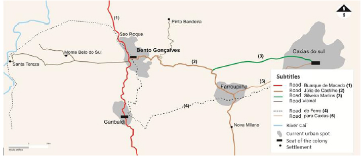
Source: The authors (2015)
Figure 4 Connection of Bento Gonçalves with the former seats of the colonies (1875)
As reference of the migrants' arrivals in the colonial areas there are the localities of Santa Tereza, Monte Belo do Sul, and Pinto Bandeira. These are important grape growing areas, although away from the seat of the colony. The proximity of the Taquari River basin gave the first two localities a key role in the fluvial transport of goods, particularly due to the natural harbor and the road between Dona Isabel and Santa Tereza. This characteristic enables the construction of a small port area contrasting with a poor road infrastructure. Concomitantly, Buarque de Macedo road structures linearly the rural and urban space of Dona Isabel Colony (Figure 4). These possibilities reproduce spatially the roads, reinforcing their importance in the structure and development of the city throughout the time. In this way:
In the center few streets kept their line. Gradually, the city grew to the east, toward Buarque de Macedo road, then to the railroad, and then to the [state] highway (...). However, to the west the city remains within the limits established in the original project (Giron; Nascimento; 2010, p. 82).
The construction of the railroad, in 1910, changed the distribution of goods, however, it brought urban value. The goods that before were sent by road transport began to be moved through a new route to Porto Alegre, which promoted a new intraregional axis, by railway. It began where is now the central area of Bento Gonçalves, connecting to Coronel Pilar district (Figure 5). This was called the "road to Taquari River" and it was important at the time. Another key access connected to Santa Maria da Soledade do Forromeco Colony, currently the road to São Vendelino, establishing the expansion limit of the city to the east
Conde d'Eu Colony does not justifies its pioneering role in the settlement in the same proportion of the socio-economic growth. Its original urban core, today the central area of Garibaldi, has a regular layout even though it is located in rough terrain. Afterwards, Conde d'Eu stops being the main destination for the immigrants due to the greater development of seat Caxias, and for political reasons. Created in 1870, it becomes parish of São Pedro de Conde d'Eu, in 1884. Later, in 1917, the railroad arrives to Garibaldi (Clemente; Ungareti. 1993). Initially, "[...] the biggest obstacle to population growth of Conde d'Eu was the lack of connection with the other villages, because the tracks opened by the staff of the Land Comission did not resist long without maintenance" (Clemente; Ungareti, 1993, p. 53). In the district of Coronel Pilar, west of its seat, is where the major part of the goods of the colony are distributed, through the Taquari River, and defining new strengths and values for the development of the locality.
The first administrative urban seat of Caxias Colony was Nova Milano, and it was a reference for arriving immigrants. Later, for geographical reasons and political influence, the administration was transferred to a place near the fifth league, Campo dos Bugres. There, seat Dante rises, a project based on a rigid urban layout, which today can be seen in the center of Caxias do Sul. Regarding this transferal, it is reported that "[...] by the end of 1875 the president of the Province responding to the wishes of Luiz Antônio Feijó Júnior transferred the seat of the Colony from Nova Milano to the center of the great forest, yet to be colonized" (Gardelin, Costa, 1993, p. 73). Regarding this influential individual, it is known that he possessed a sesmaria (land grant) in Serra Gaúcha, before the colonization process. With the transferal of the administration to seat Dante, located in the easterner limit, his lands became more valuable. So, "Luiz Antonio Feijó Júnior also subdivided the sesmaria, becoming one of the richest man in Caxias Colony" (Giron; Nascimento, 2010, p. 123). In this scenario, it is considered that he was the first big beneficiary of the urban and land ownership logic of Caxias do Sul, besides being the great instigator of the transferal of the seat of the colony, promoting specific interests regarding the valuation of his lands located near the new seat.
Another socio-economic logic, and road system, is established with the seat in Dante. The third league, with Visconde do Rio Branco road, became the interregional connection point, with access to the capital of the province. This condition benefited some individuals, as was the case of a French man, Henri Frederich Benet, local resident, who establishes a grocery store and, later, an inn. Another example of this locational bond is the foundation of the Lanifício Rossi (textile), and, subsequently the Galópolis neighborhood, in the fourth league.
The area was, thus, shaped both as a residential and industrial cluster for former workers coming from the region of Schio (Italy). In the distribution of its leagues, that Colony "was not square as Conde d'Eu, nor rectangular as Dona Isabel, but it expanded east, then it went north in a J-shaped configuration" (Giron; Nascimento; 2010). It had a radius access structure. In 1877, Conselheiro Dantas (Figure 6) road is built following the incentives to settle in the eight league, the border area of S São Francisco de Paula. It went through the hamlet of Ana Rech, named after the first grocery owner in that place, which supplied the tropeiros (muleteers) in the outskirts of the colony seat. This road, concluded in 1918, was important to the consolidation of the hamlet of São Marcos and it ended its isolation.
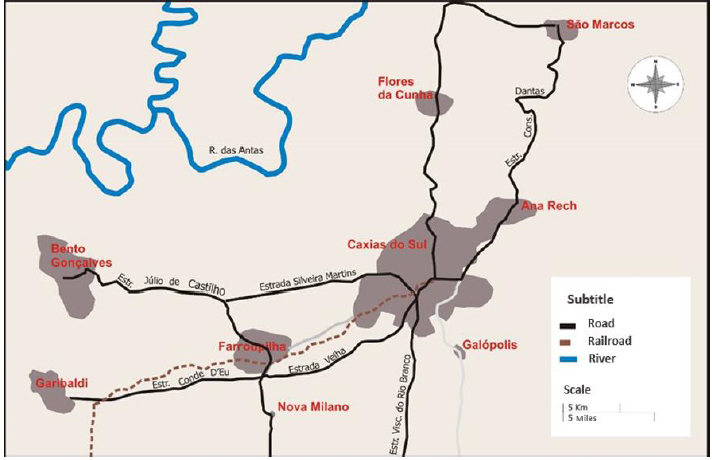
Source: The authors (2015)
Figure 6 Connection of Caxias do Sul with the former seats of the colonies, in 1918
In 1884, Caxias leaves the condition of colony and becomes part of São Sebastião do Caí. The former colony was divided in three seats: Dante, Nova Trento and Nova Milano. From São Sebastião do Caí to Campo dos Bugres (region of Dante), the main connection road was Visconde do Rio Branco, which extended to the second seat, which was Nova Trento, now Flores da Cunha. Nova Milano, however, set aside from the socio-economic development.
In 1910, the construction of the railroad from Porto Alegre to Caxias do Sul changes the economy of the municipality of Caxias. It had become, then, a privileged location among the municipalities of Serra Gaúcha, however, the districts of Nova Trento and São Marcos managed to keep up with the growth. "In just a few years, the location of Caxias has proven to be advantageous because it was half way between the former German colonies and the new Italian colonies" (Giron, Nascimento; 2010, p. 27).
The decline of Nova Milano coincides with the period of formation of a new municipality between the three colonies. Thus, Farroupilha becomes a municipality incorporating part of the lands of Feijó Junior to the seat of Nova Milano and part of Conde D'Eu and Dona Isabel.
3.1 Procedures of regional occupation
It is known that the main centers of each colony were planned by the Imperial Government, according to orthogonal layout. When the first immigrants arrived the seats of the colonies were already defined, with their urban project, and the areas for agriculture were organized in regular lots. Another relevant aspect of the settlement in the colonies was the great amount of available land and the government's subsidies to land use.
A peculiar fact was the linear settlement of spatial occupation in the three colonies (Figure 7). In Caxias do Sul, the Ana Rech neighborhood was a classic linear village, a transit point for tropeiros (mulleteers). In Bento Gonçalves, the so-called Caminhos de Pedra, was also marked by that feature of territorial settlement, besides being a connection road between Caxias and Conde D'Eu. In the city of Garibaldi, Coronel Pilar and Daltro Filho, planned as passageways to the Caí River, also presented the same feature of settlement. In this kind of occupation the immigrants became agents of the privatization and subdivision of the social space produced, and structured the urban-territorial environment. In those space appropriations there was no planning for the roads, they followed the topography. The first roads to arrive to a given point can still be perceived today, through the differentiated trace. However, with the urban expansion the trace can be observed in the seats of the municipalities. Currently, the trace in Bento Gonçalves and Garibaldi, by Buarque de Macedo road, and in Caxias, by Visconde do Rio Branco old road, establish sinuous avenues in the cities. That also happens in Farroupilha, in Júlio de Castilhos road.
Source: The authors (2015)
Figure 7 Distribution of the routes overlapping the roads of regional formation
The migrant flows encouraged the emergence of a society of peasants or settlers following Italian patterns (Frosi; Mioranza; 2009). However, as the industry and commerce develop the acculturation begins eroding Italian traditions. The internal migrations decrease and the dislocation of farmers to the industry increases. Thus, leading attractors determine rural exodus and, often, the abandonment of agriculture. According to Herédia (1997) there are four economic cycles in the history of the colonies. In the first cycle the colonization and the small farms are encouraged. In the second, the commerce is strengthened and the small-scale industry appears. The third moment is marked by the abandonment of the countryside and, in the fourth, the presence of large-scale industry, which encouraged farm people to leave their properties and head to the cities
Caxias do Sul assumes a prominent position, becoming the main center in the region, with an important commercial activity. The Commercial Association of Caxias [do Sul], created in 1901, takes position as the commercial regional interlocutor for selling the surplus production from the small farms. The change could have been either motivated by political influences or lack of quality of some of the roads, or other factors, such as the consolidation of the hierarchy of the places.
Caxias Colony, from the times it had its seat in Nova Milano, was directly connected to Dona Isabel, and later, the new seat also was connected to this other colony through Palmira line. This can be justified by the fact that the Colony had become a reference to all the others and, thus, it distributed to Dona Isabel a greater number of migrants, to the detriment of Conde d'Eu Colony. In this way, it can be observed that the cities of Caxias do Sul and Bento Gonçalves grew faster given their connections, among other territorial issues
The cities of Serra Gaúcha are articulated with each other, either economically, culturally and politically. They form urban networks which may be examined at different scales, as refers Bruna (1983). These cities range from small cores, almost centerless, only influencing the municipality to which they are the seat, to great metropolises. Along the roads there are places of various sizes and centers. However, the presence at least of one urban attractor justifies the formation of a region. Thus, this must be acknowledged and not made up. Given the inventory made in this study, the initial structure of the cities is examined again.
Currently, Farroupilha holds its position in the distribution of part of the local road system, with new modern roads. Meanwhile, the colonial routes, connection roads between the various places, as Caxias do Sul and Bento Gonçalves, are less used because they are sinuous, low-quality pathways. This scenario leads to investigations. Some of those roads have become drafts and resources of modern regional roads. However, their role as the backbone of colonization and the quotidian dimension is found noticeably along them, with several common recreational areas, among chapels, houses and services. There is also a strong cultural appeal from the immigration process which is rooted in the inhabitants' memory, descending from those former immigrants. The cultural tourism in region draws on the routes made by the colonial roads. Hence, this scenario of confrontation is presented. The recognition of its potential, as a resource for a tourism product is sought.
3.2 Routes in Serra Gaúcha
Tourism in Serra Gaúcha is based on three key resources. The culture of Italian immigration, grape growing, and the wine industry which refers to the cultural memory and adds value to the region. The tourist appeal is built upon these local identity values, which enhance the destination attractiveness and thus "(...) they have the responsibility of spreading the development of the routes to which they belong and, therefore, the tourist regions they cross" (Tomazzoni; Possamai; Lovatel, 2010, p. 17).
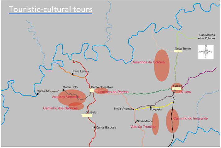
In the region of Serra Gaúcha, there are the following cultural routes: Caminhos de Pedra, Vale dos Vinhedos, Caminhos da Colônia and Estrada do Imigrante (Brambatti, 2005). The Caminhos de Pedra is located in the communities and lines of São Pedro, Palmeiro, and Santo Antônio. The Vale dos Vinhedos, in Leopoldina; Oito da Graciema; Graciema; Seis da Leopoldina; and Quarenta da Leopoldina, both in Bento Gonçalves. The Caminhos da Colônia, in Otávio Rocha, specifically in Flores da Cunha passing by the line forty and Travessão Thompson, in Caxias do Sul. The Estrada do Imigrante is located in Travessão Cristal and Santa Rita, also in Caxias do Sul. These are the first consolidated routes in the studied area. Adding to these, there are the urban routes La Cittá, and the Vale Trentino, in Caxias do Sul, as well as the Estrada dos Sabores, in Garibaldi. As mentioned in the methodology section, the routes still under development and/or related to sports and nature, and sightseeing, as those of Criúva, in the interior of Caxias do Sul, are not considered in this research.
It is observed, by overlapping the tourism routes and the roads under analysis that the values generated in the historical, urban, and regional formation are present when these values refer to a historic context. Thus, three routes are directly defined by the original trace. Among these, the Estrada do Imigrante and the Caminhos de Pedra make reference to the spatial distribution of olden times. The former defines, as its name indicates (Immigrant Road), that condition of memorial temporality. The references, so-called historical, are mostly memorial constructions and tourism positioning rather than interlocutors of the regional settlement process.
The Vale dos Vinhedos route is structured by the vineyards. Individually, there are projects of visit in which the guide resorts to the memory of the historical path of the entrepreneur, as owner and as a descendant of Italian immigrants. However, it is not established a connection with the initial process of settlement, the initial family farming or with the colonial routes.
The Caminhos da Colônia is not spatially related to colonial routes. Probably, the initiative stems from a sporadic idea of creating a "route in time" drawing on the colonial mores. Only in this sense would this route be justified, although its itinerary, a series of paths without a logical definition of points justifies the plural Caminhos (paths). In the route Caminho dos Sabores there is no historical or territorial association with the colonial settlement. These proposals would benefit from associated management.
4 FINAL CONSIDERATIONS
The identification of the general panorama of the settlement in Serra Gaúcha gave rise to the following issues: the characterization of this agro-colonial settlement region; the identification of the formation of the primitive populated; and through this establish the relationship between the flows that identify the access routes and the distribution of people and goods, thus shaping a region, or regions, culturally, geographically (physical and morphological features), socioeconomically and through networks.
The networks as subject of research are reinforced, considering their values in the socioeconomic and cultural definition. Specifically for tourism the individual is moved from their superstructure frame to a dimension closer to the quotidian. This confrontation between the trivial space and the spatial reproductions of the appropriation, or not, by visitors enables the recognition of the establishment of the Tourism Routes in question. In this way, the study of the historical and cultural routes uncovers the historical and cultural relation between the access routes and the tourism product. Meanwhile, the tourism products, which could contribute to the consolidation of the regional structures, characteristic of an area built upon these socio-spatial foundations, fail to achieve this goal.
A route may embody the values of memory and identity. These visit paths are justified by tourism opportunities. In this sense, an association of entrepreneurs is necessary, to the detriment of a legacy, or as professor Milton Santos puts it "scars of the spatial production", which send to the past. Thus, a further unfolding of the tourism product should entail a consolidation of the cultural routes built upon new physical and territorial bases.
It is noteworthy that the current routes are relatively new, in terms of a commercial product. Strategies of requalification and new positioning are put forward at each moment for those areas of visit. The wine tourism and its routes are an exception justified by its commercial appeal, as it is the example of Vale dos Vinhedos. However, a historical and territorial compromise may establish new values upon which a long-term tourism product is created.

